Languages
15Pont du Gard Audio Guide
Pont du Gard is a landmark in Vers-Pont-du-Gard, France. Explore it with Stanza's GPS-triggered offline audio guide — available in 15 languages.
Quick Facts
13
Stops
15
Languages
100%
Offline
📍 Vers-Pont-du-Gard, France · 43.9473°N, 4.5355°E
About Pont du Gard
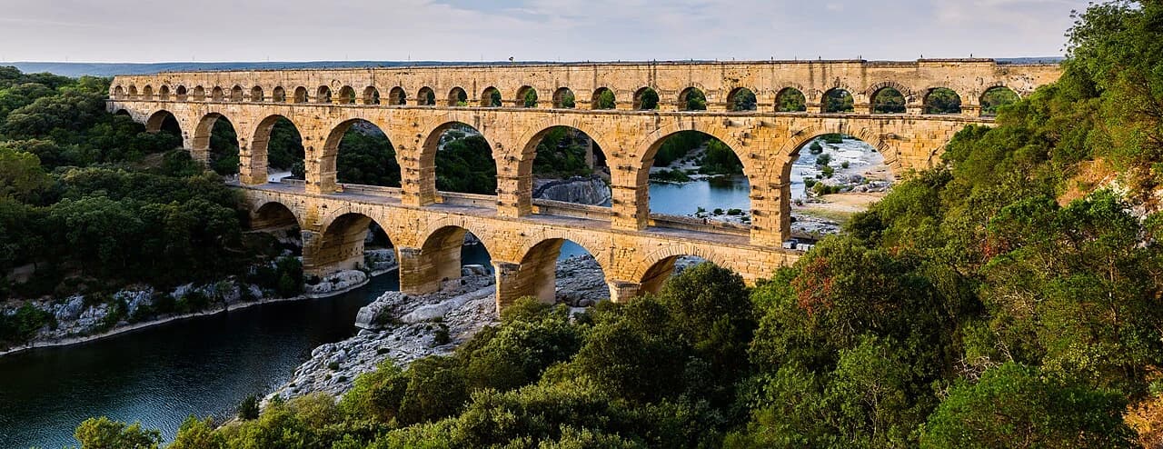
The Pont du Gard is an ancient Roman aqueduct bridge that crosses the Gardon River. It is a UNESCO World Heritage site and a significant example of Roman engineering.
Pont du Gard is also known as Le Pont du Gard, pont du Garde, pont du Gard.
This self-guided audio tour features 13 narrated stops organized across 9 sections. As a bridge, Pont du Gard offers a unique cultural experience in the heart of Vers-Pont-du-Gard, France.
The Stanza audio guide is available in 15 languages and works entirely offline — download the complete tour including audio narration, maps, and images before your visit. As you walk through Pont du Gard, GPS-triggered narration plays automatically at each point of interest.
Last updated:
What you will hear
The Museum of the Pont du Gard
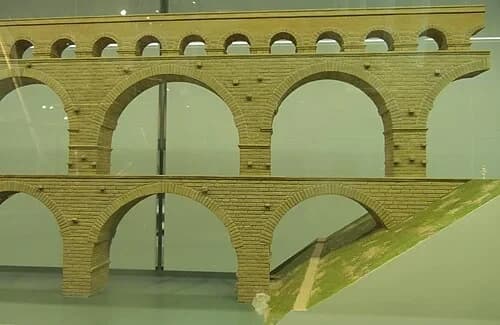
Start at the modern visitor center to understand the scale of the 50km aqueduct system. Need: museum entrance and a model showing the engineering context.
Engineering Scale Model
This model reveals the hidden mechanics of the entire aqueduct system. Construction began roughly between 40 and 50 AD, requiring a massive effort that spanned about 15 years. A workforce of up to 1,000 laborers worked on this specific section alone. While the bridge is famous, the most impressive feat is the math behind it. The entire 50-kilometer channel drops only 24.8 centimeters per kilometer. That means for every 182 meters of length, the height only decreases by a single centimeter. This subtle, constant slope ensured that gravity kept the water moving at exactly the right speed, preventing it from stagnating or moving too fast and damaging the interior structure. This level of precision over such a long distance was unprecedented and remained unsurpassed for over a thousand years, proving that Roman engineers had mastered the art of surveying long before modern technology existed.
The Ancient Olive Grove
Walk through the Garrigue landscape. Need: a shot of the millennium-old olive trees that line the approach.
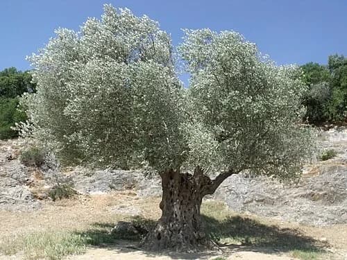
The Millennium Olive Tree
Before reaching the bridge, the surrounding landscape offers its own ancient story. This olive tree, originally brought here from Spain, has lived for over 1,000 years. Its gnarled, twisted trunk and silvery leaves are characteristic of the 'Garrigue'—the low, scrubby vegetation of the Mediterranean limestone region. The tree stands as a living bridge between the natural world and the massive stone structure ahead. While the Roman bridge was already a millennium old when this tree was planted, both have survived the same harsh winds and intense summer heat. The scent of wild thyme and rosemary often fills the air here, providing a sensory backdrop to the engineering marvel you are about to encounter. This environment provided the limestone for the bridge and the fuel for the workers, showing how the Romans integrated their grandest projects directly into the resources of the local terrain.
The Grotte de la Salpêtrière
A prehistoric cave near the bridge path. Need: the POI primary image to tell the legend of King Charles IX's visit.
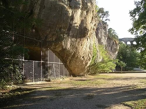
The Nymph's Cave
Not everything here is about engineering; some stories are purely whimsical. Tradition holds that in 1564, King Charles IX visited this site. To welcome the young monarch, local residents staged an elaborate performance. Twelve local girls, dressed as mythological nymphs, suddenly emerged from this cave to present the king with baskets of pastries and fresh fruit. This lighthearted event adds a soft, human layer to a site otherwise dominated by massive stone pillars and mathematical precision. It reminds us that for centuries, the Pont du Gard has served as a place of wonder and celebration, long after its original purpose as a water carrier was forgotten. The cave itself is a natural feature of the limestone cliffs, showing how the local community utilized every aspect of the landscape to honor visitors and maintain the site's status as a local landmark of great pride.
The Visual Threshold: First Grand View
The moment the full scale of the bridge is revealed from the left bank. Need: a clear, wide panoramic establishing shot.
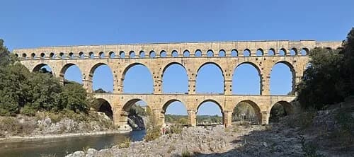
The Three-Tiered Giant
The full scale of the structure is now clear. Standing 48.8 meters high, this is the tallest Roman aqueduct bridge ever built. It consists of three distinct tiers: six massive arches at the bottom, eleven in the middle, and thirty-five smaller arches along the very top. This layout wasn't just for aesthetics; it distributed the weight of the structure while allowing the river below to flow freely, especially during seasonal surges. Its exceptional preservation and the creative genius required to build it earned the site UNESCO World Heritage status. Even from a distance, the rhythm of the arches creates a sense of lightness that masks the tens of thousands of tons of stone used in its construction. This bridge was just one link in a 50-kilometer chain, but it remains the most iconic because of how it elegantly solves the problem of crossing the wide Gardon valley.
Secrets of Roman Masonry
Examine the construction techniques up close. Need: detail of the blocks and the protruding scaffolding supports (bossages).
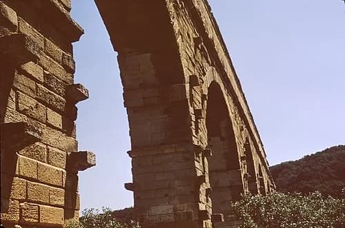
Construction Scaffolding Marks
Look closely at the stone pillars for square, protruding blocks. These aren't mistakes or decorative features; Roman engineers called them 'bossages.' During construction, these blocks supported the massive wooden scaffolding, known as centring, which held the stones in place until the final keystone was set. Interestingly, the Romans chose not to carve them away once the job was finished. They left them as permanent supports for future maintenance workers to use when they needed to inspect or repair the higher levels. These marks offer a direct look at the logistical planning of the original builders, showing that they weren't just thinking about the initial build, but about the long-term survival of the structure. It proves that maintenance was part of the original design philosophy, ensuring that workers could safely access the heights of the bridge for generations to come.
The Middle Tier: Engineering a Giant
The largest arches of the structure. Need: a vertical or angled view highlighting the scale of the middle tier.
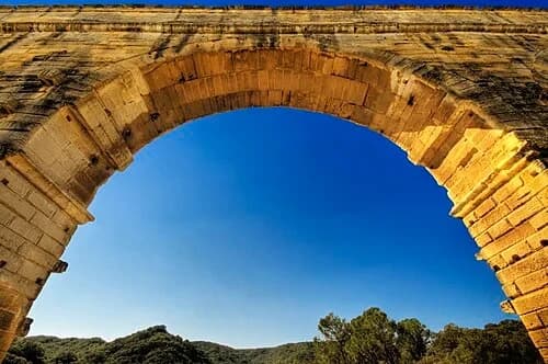
The Power of the Arch
The curve of a single arch is a marvel of physics. In this design, the stones are cut into wedge shapes called voussoirs. The weight of the structure pushes these stones together, actually making the arch stronger as more pressure is applied. This distributed the load of the massive limestone blocks down through the pillars and into the bedrock below the river. This engineering choice allowed the Romans to create a bridge that feels remarkably open despite its enormous mass. Because the arches offer so little resistance to the wind, the bridge has survived two millennia of powerful Mediterranean storms and the relentless pull of gravity that would have flattened a solid wall. This airy design was essential for surviving the intense regional winds, showing how the architects accounted for the natural forces of the valley to ensure the bridge's permanence.
Inside the Specus: The Water’s Path
The top level where the water flowed. Need: interior and top-down views of the conduit.
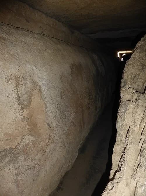
Inside the Water Channel
At the very top of the bridge lies the 'specus,' or the water channel. This narrow, covered conduit was the heart of the entire system. Life for the maintenance workers, known as 'circitores,' was often difficult. They had to crawl through this confined space to manually scrub away thick layers of calcium and mineral deposits. If left unchecked, these deposits—built up from the hard water of the Eure spring—would eventually narrow the channel and slow the flow of water to the city. You can still see the remains of these deposits on the walls today, looking like thick, rough bark or mineralized stone. It is a reminder that the aqueduct wasn't just a static monument, but a living machine that required constant human attention to function. These workers were the unsung guardians of the city's health, ensuring the water flowed cleanly for centuries.
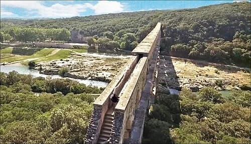
The Summit Walkway
From this height, the volume of the project becomes truly apparent. Every day, approximately 40,000 cubic meters of water rushed through this channel on its way to the baths and fountains of the city of Nîmes. To prevent leaks, the Romans lined the interior of the channel with a special waterproof mortar called 'maltha.' This ancient sealant was a mixture of lime, pork fat, and milk. The fat and proteins reacted with the lime to create a durable, water-resistant surface that protected the limestone structure from erosion and seepage. This clever use of organic materials ensured that the precious water reached its destination without leaking through the stone, maintaining the pressure needed to serve the city's growing population. The flat roof stones above the channel also protected the water from dust and sunlight, preventing evaporation and the growth of algae during its long transit.
The Historic Moulin
Downstream view toward the old mill. Need: a view of the riverside building to provide historical context of the site's later uses.
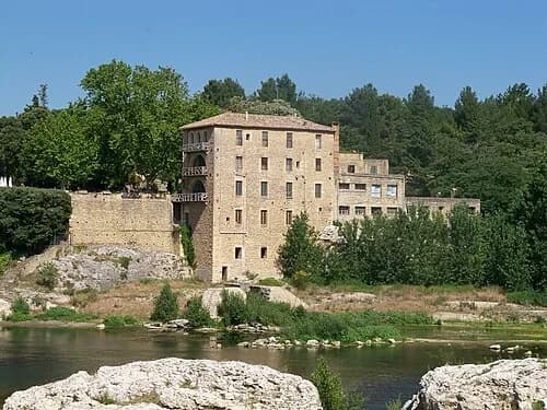
The Old Mill
The story of this site continued long after the Roman Empire faded. This riverside mill building represents a new era for the bridge. Once the aqueduct stopped carrying water, the structure became primarily a river crossing and a source of local industry. Because it was one of the few reliable ways to cross the Gardon River, it turned into a valuable toll point. Local industry flourished here, using the river's power to grind grain and support trade for nearby villages. For centuries, the bridge was more than just an ancient ruin; it was a vital piece of infrastructure that sustained the local economy. The mill stands as a reminder of how communities adapted the monumental ruins of the past to meet the practical needs of later generations, ensuring the bridge remained useful long after its original purpose was lost to history.
The Climax: Reflections on the Gardon
The final stop on the riverbank. Need: the iconic symmetrical reflection shot to discuss the bridge's survival and floods.
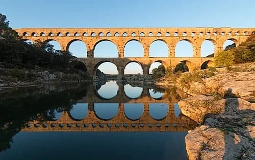
Reflections on Survival
Standing on the riverbank, the symmetry of the arches reflects in the water below. This bridge has survived more than just time; it has withstood the 'Gardonades'—the violent flash floods that occasionally surge through this valley. In 2002, a massive flood saw the water rise nearly to the top of the first tier of arches, yet the bridge stood firm while modern structures nearby were swept away. Over two thousand years, the limestone has weathered from its original grey to a warm, golden hue, a color created by the slow oxidation of iron within the stone. These subtle shifts in color and the small plants growing in the crevices are the only signs that this structure has been standing since the time of the Caesars. Its survival is a testament to the fact that when things are built with enough precision and mass, they can outlast the civilizations that created them.
Want to hear the rest?
Download the Stanza app to unlock all 13 stops and full GPS-guided navigation.
Frequently Asked Questions
How long does the Pont du Gard audio tour take?
The Pont du Gard audio guide includes 13 narrated stops. Most visitors spend 45 minutes to 1.5 hours exploring the complete tour, though you can listen at your own pace and skip or revisit any stop.
Is the Pont du Gard audio guide available in my language?
Stanza supports 15 languages: English, Spanish, French, German, Italian, Portuguese, Russian, Japanese, Chinese, Korean, Arabic, Hindi, Polish, Dutch, Hebrew. Check the guide in the app to confirm the languages currently available for this tour.
Can I use the audio guide offline at Pont du Gard?
Yes! Download the complete Pont du Gard tour — including all audio, maps, and images — before your visit. The Stanza app works completely offline, so you don't need WiFi or mobile data at the venue.
How much does the Pont du Gard audio guide cost?
The Stanza app is free to download. The current listed price for the Pont du Gard audio guide is $1.99; app-store region and currency may affect the final price.
How do I use the Stanza audio guide at Pont du Gard?
Download the free Stanza app, search for "Pont du Gard", and download the tour. When you arrive at the venue, the app uses GPS to detect your location and automatically plays the relevant narration as you move between points of interest — completely hands-free.
What makes the Stanza audio guide different from other Pont du Gard tours?
Stanza offers GPS-triggered narration that plays automatically as you walk through Pont du Gard — no need to manually select stops. The tour is available in 15 languages, works fully offline, and includes 13 expertly narrated stops with images and historical context.
What other audio guides are available near Pont du Gard?
Stanza offers multiple audio guides in Vers-Pont-du-Gard, France and nearby areas. After downloading the app, browse the map to discover all available tours near Pont du Gard. Each guide can be downloaded for offline use.